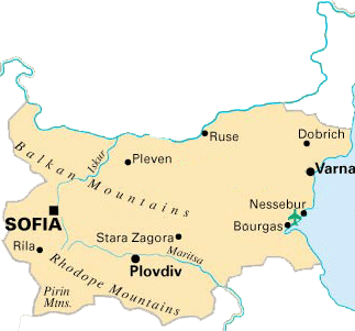
Map of bulgaria is situated in southeastern Europe. Map of bulgaria occupies the northeastern part of the Balkan Peninsula. On bulgaria map towards the North, it borders on Romania, to the West it borders on Serbia, Montenegro and Yugoslav Republic of Macedonia. Bulgaria has its neighbors Greece and Turkey on the south. While on the east Bulgaria touches the Black Sea, which links it also to Russia, Ukraine, and Georgia. The Black Sea borderline is 378 km (240 miles) long. The country’s total territory is 111 000 sq. km (43 000 sq. miles).
On the map Bulgaria the Balkan Mountains cross the country reaching to the edge of the Black Sea and its golden beaches. The land is heavily cultivated, covered with forests and crossed by rivers. Although Bulgaria lies in the very southeast corner of Europe, the climate is never extreme in summer, even on the red-earthed plains of Southern Thrace. |